The Lake Michigan Circle Tour is an approximately 1,100 mile loop around Lake Michigan. It can be completed either clockwise or counter-clockwise. We’ve driven it twice, once in 1993 for our honeymoon and again in 2013 for our 20th anniversary. Both of those were clockwise loops. This time I’m riding counter-clockwise with the start coinsiding with this year’s
Le Tour de Shore.
This is my fifth time riding Le Tour de Shore. It supports a good cause and is the most cost-effective bike trip I’ve seen. Each year I’ve done the tour I’ve added on to it somehow. At first, I just started from home and took an extra day. Then I started in Wisconsin and took an extra two days. Then I started in Iowa and took an extra six days.
Last year I was planning to ride to Mackinac Island but ended up needing to finish a coding project that kept me from going further than Michigan City. So, with a little luck, this year will go all the way around and back home again.
Palatine to Chicago
Day 1: 39 miles, 500 feet of elevation gain. The weather was a bit cool and hazy / overcast with wind off the lake.
There are shorter ways to get downtown than the path I take, but those require a lot of time in bike lanes on major streets. I prefer forest preserves and bike paths whenever possible, so my route is a bit longer. But it’s also much safer and prettier. Today I got to see a deer along the trail and was able to stop for late lunch along the lakefront just south of Belmont Harbor. It’s a nice route, and highly recommended for anyone coming from the northwest suburbs to downtown.
I stayed at the Central Loop Hotel, four blocks from Michigan Avenue and about eight blocks from Buckingham Fountain. It seemed to be a nice hotel, better than any of the others I’ve tried downtown in the last few years. There is a food hall / food court nearby and I had a double-cheeseburger, fries, and a local beer for dinner. Everything was good.
I then walked down to the fountain and took a picture. On the way back I noticed a significant police presence. An anti-ICE protest had gone down Michigan Avenue about 15 minutes before I arrived. As I walked back to the hotel, I ended up just one block over from the protest. Lots of police, but I didn’t notice any disruptions otherwise. What I did notice besides the police were a large number of Streets and Sanitation snow plow trucks completely loaded with either sand or salt standing by ready to block either traffic or protesters as needed.
Chicago to Indiana Dunes
Day 2: 63 miles, 700 feet of elevation gain. Weather was cool and overcast with occasional rain. Not quite enough to put on a jacket, just enough to be wet occasionally.
This was Day 1 of Le Tour de Shore. Almost 700 riders were registered. The weather may have encouraged some to stay home, but it was a nice ride with a tailwind down the lake. It’s a full SAG ride, with pancake breakfast in Whiting, PB&J lunch in Griffith, smoothies on your own in Hobart, and usually a stop at the bar in Porter.
The rain was forecast to increase in the afternoon, so I decided to go straight to the campground and get set up on dry ground first. Then I went over to the Pavilion Rooftop bar for a beer and a snack and then walked the beach for a bit. I met a couple from Washington, DC riding bikes. They were driving in a big circle from Indiana down to Texas and back to Georgia and then up the coast again. We talked about different biking options they had along the way. Then I went back to camp for dinner.
Dinner was very good, including chicken, ribs, mostaccioli, and potato salad. Then we sat around a fire until almost dark before turning in. Some people had problems with raccoons overnight (chewed up rain ponchos and bags), but all I heard was a deer snorting and stomping in the middle of the night.
Indiana Dunes to South Haven

Day 3: 78 miles, 1,600 feet of elevation gain. The weather was quite cool in the morning with wind off the lake.
Day 2 of Le Tour de Shore is scheduled for 43 miles and includes snacks in Michigan City and Three Oaks and then Redamak’s burgers in New Buffalo. I did the first 20 miles and then turned off toward the finish line for an early burger and to save my energy for the rest of the day. Lunch was good.
Then I headed off on my own. It’s always a strange feeling leaving a tour and going off by yourself. With a group there’s usually someone ahead of you to give you an idea of where you’re going and someone behind you to help pick up the pieces if something goes wrong. On your own, there’s no one to save your ass for you. Pay attention, watch the traffic, ride defensively, and keep track of food and water options.
I basically followed USBR 35, labeled M35 in Michigan. There’s a good RideWithGPS map available on the
Michigan.gov website. Unfortunately, I didn’t download this map until later in the trip. I started by following the Adventure Cycling map and combining that with Google Maps. The Adventure Cycling map seems a bit out of date. And Google generally takes the fastest route rather than the prettiest route.
The early part of the ride was lakeshore side streets. Some of the rest was bike path and bike lane, but most of it was riding the shoulder. The shoulder is pretty good in most places, but a bit narrow or missing in others. But most traffic was good. I only had to bail out once when a long-haul cement truck refused to move over, even though there was no one in the open lane beside him.
I stopped for pizza at DiMaggio’s Pizza and Burgers, the last restaurant option before Van Buren State Park. While there I met two couples having dinner who asked about my ride. After dinner I had a half-pizza left over and shared it with the couples. No refrigerator at the campground.
Michigan State Parks have a “No Turn Away” policy for anyone arriving under their own power (walk, bike, kayak, etc.). The campground was full, so I got the entire youth camp / group camp area all to myself. I was probably a quarter-mile from everyone else, a very quiet evening, except for two things. One, there was a pair of whip-poor-wills that called to each other just before dark. And two, the campground is surprisingly close to the Palisades Nuclear Power Plant. It sounded a little like traffic noise to start with, but there was a constant whirr all night from the generators or pumps, etc.
South Haven to Norton Shores
Day 4: 74 miles, 1,500 feet of elevation gain. It was sunny and warm today.
The morning ride was similar to yesterday with shoulder riding and some stunning lakeshore views. As I was riding along, a bald eagle swooped down in front of me to get something along the road. It then flew back up to its perch.
The afternoon was mostly bike path beside the road. Along the way I met a couple, Joanne and Ralph from Kentucky, who have ridden in more countries than I have states. They had come up from Kentucky and were planning to do the full circle tour. Ralph is retired and Joanne is an elementary school teacher who has the summer off.
I ended up riding with Joanne and Ralph for a couple of hours and we had lunch at Wendy’s in Holland. Near Grand Haven they decided they wanted to stop for awhile and I continued up to P J Hoffmaster State Park. As I was setting up my tent, another biker rode in. Sarah is from Chicago and was doing the Circle Tour clockwise. She has been touring for many years and this is her third time completing the Circle Tour.
As I was leaving to find dinner, I saw Joanne and Ralph and told them where we were camping. So it ended up being the four of us in a row with Joanne and Ralph in the middle. We all talked about riding while they made dinner. Then Sarah and I turned in and Ralph and Joanne headed off to watch the sunset. Hoffmaster campground is very quiet, and I heard a couple of great horned owls overnight.
Norton Shores to Ludington
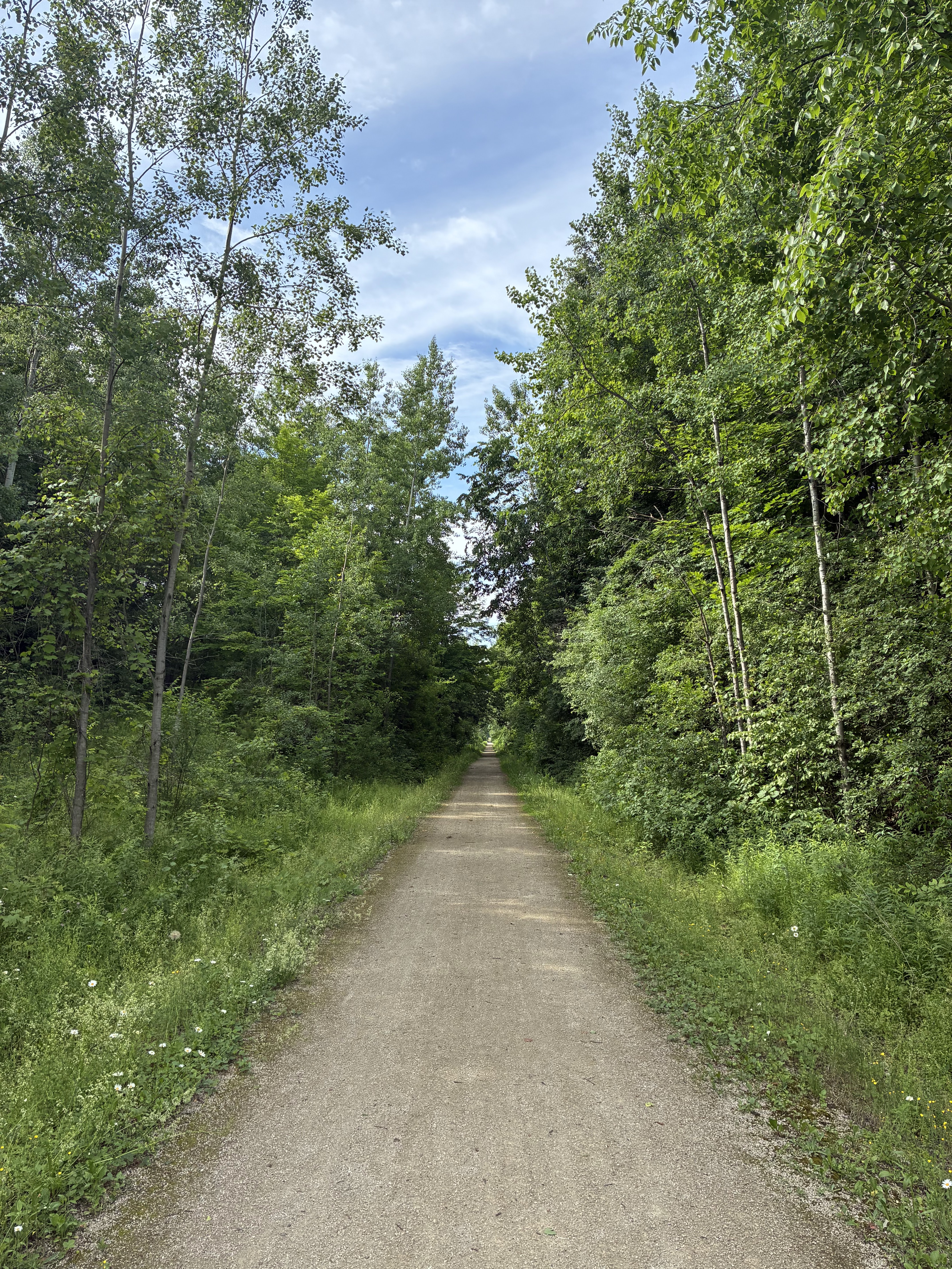
Day 5: 71 miles, 1,500 feet of elevation gain. The weather today was very warm with a bit of a tailwind. Most of today’s ride was a bike trail from Muskegon to Hart. It was beautiful, and reminded me of Day 2 of USBR 20 south of Fargo in Minnesota. I would definitely ride that trail often if I was in the area.
The last 20 miles, however, were less bike-friendly. The shoulder was in very poor shape and the traffic was frequent enough to make it quite stressful. The only place I really felt unsafe was on Michigan 10 in Ludington itself. There is no shoulder, the sidewalk is intermittent and doesn’t have curb cutouts, etc. But I survived and only had to “salute” one driver.
Along the way on the bike trail I stopped and talked with a couple from the area who were out for a short ride. I told them my plans and they cautioned me that Ludington State Park was a good five miles out of the way, both in and out of the park. So I decided to get a hotel room for the evening. I stayed at the Best Western. The staff was very accommodating. China Buffet was right down the street, so that was dinner. It was good.
Ludington to Beulah
Day 6: 68 miles, 2,300 feet of elevation gain. Weather was quite warm again, but very pleasant when the wind comes off the lake.
Today was much more rural back roads and side roads, with occasional shoulder riding. There were also very nice lake views from time to time. And, there were significant climbing opportunities. One was a two-mile hill that peaked at 11%. Another was a half-mile climb that seemed steeper. I made it up the first climb but decided to walk the second. There were one or two more climbs after that, but more manageable.
During the first climb I was passed by a number of distance cyclists who were much younger and carrying no weight. They must have had a chase vehicle somewhere. Anyway, they were waiting at the top of the hill for some of their members and cheered me on. Then they all passed me on the way down the other side.
I had lunch at The Outsider in Manistee and dinner at Five Shores Brewing in Beulah. Because of predicted rain overnight, I decided to stay in a motel, the Coastal Inn. It was surprisingly good. It’s a typical older roadside motel on the outside, but the room was very current and well-maintained. And the hosts were very responsive to questions. I would definitely stay there again if I was in the area.
Beulah to Interlochen
Day 7: 27 miles, 500 feet of elevation gain. Weather today was wet. Not quite wet enough for a rain jacket, but close. The original forecast was for 2 inches of rain today. It ended up more in the 1-inch range. But, still, not a fun day for biking.
I have a friend who has a friend who has a cabin on Duck Lake. I was offered the opportunity to stop at the cabin long before I knew the weather forecast. Originally I had planned to head further north and visit Sleeping Bear Dunes and Suttons Bay. Sleeping Bear Dunes is very pretty, and I’ve heard the same about Suttons Bay. But, neither one is much fun in the rain, so I detoured to the cabin for a rest afternoon instead.
I stopped at the grocery store, picked up lunch, afternoon snack, dinner, and a four-pack of White Zinfandel. Sitting in a screened-in sun-porch overlooking a lake while sipping wine beats riding in the rain any day.
Interlochen to Charlevoix
Day 8: 74 miles, 2,000 feet of elevation gain. The weather started out overcast. The rain ended overnight, but there were puddles everywhere. All of the sand / gravel roads were still wet.
Today was a love-hate relationship with Google Maps. On the one hand, all of the pictures I took along the route today were from Google detours. On the other hand, at least 5 extra miles and 1,000 extra feet of elevation gain were from Google detours. It was too wet to take any of the sand / gravel roads Google wanted me to take. And the roads switched to sand unexpectedly.
The alternative was a lot of shoulder time on US 31. It’s mostly a good shoulder, six feet wide. So, that wasn’t a real issue. In fact, the only traffic problem I had all day was in the middle of nowhere on a back road when a pickup truck refused to wait 20 seconds for a car to pass coming the other way.
Other than a recommendation to follow USBR 35 unless the Google detour turns toward the lake (never away from the lake), there really wasn’t much remarkable about the trip itself. It was my least favorite day so far, and similar to Day 3. Food was convenience store sandwiches, etc.
However, my arrival at Fisherman’s Island State Park made up for it completely. Rolling in without a reservation, they put me in the auxiliary space, about 30 feet from the ranger station and 30 feet from Lake Michigan. It was a gorgeous spot, and I heard light waves crashing on the beach all evening.
While I was getting water, I met a family including a mother, father, son, and daughter-in-law. The daughter-in-law was in the area to participate in Saturday’s marathon run and the rest of the family was there to support her. This was to be her seventh marathon. The father invited me over for dinner, and they seemed to be very interested in hearing about my riding adventures.
I turned in at dusk and got a good night’s sleep.
Charlevoix to St. Ignace
Day 9: 82 miles, 1,100 feet of elevation gain. About 15 miles of that distance was on ferry rides. The weather was quite cool and foggy in the morning. That burned off mid-day and it was warm for the afternoon.
It was a slow day today. It seemed to take a long time to get warmed up. Not temperature-wise, but motion-wise. The miles are starting to add up. This ended up being another Google detour day. USBR 35 goes a little further west but stays on paved roads. Google recommended a gravel path straight up to Mackinaw City.
Ordinarily I don’t have a problem with gravel, but this had been recently raked and was very loose. Worse yet, they left deeper piles just before each road crossing. Not recommended for anything smaller than 42 mm tires. For most of the gravel I only averaged 8 MPH. It was almost double that once I hit pavement again.
After arriving in Mackinaw City, I went straight to the ferry dock. Shepler’s seems to be the best option for transporting bikes. After arriving on Mackinac Island, I had a chicken sandwich at Mighty Mac Hamburgers. Then I took a victory lap around the island, took a photo of the bridge, and got on the return ferry to St. Ignace.
I stayed at the Days Inn. Not recommended. Staff was rude and the property needs a lot of maintenance. The room was okay, but noisy whenever anyone was on the stairs outside. I had pasta dinner delivered from BC Pizza. It was good.
St. Ignace to Gould City
Day 10: 67 miles, 2,500 feet of elevation gain.
Today was a weather day. Thunderstorms until 11 a.m., rain until 3 p.m. Gale-force winds from 4 p.m. until 7 p.m. Surprisingly, the rain didn’t bother me. I put on my Gore-Tex rain suit and went for a ride. I was never cold, and only got wet from sweat rather than rain.
I stopped at a lot of convenience stores today for food. At one of the early stops there was a gentleman who asked about my trip and mentioned he was riding to Detroit next month. He recommended the Milakokia Lake Campground as a good place to stop for the evening. I took his advice and made that the target for the day. I agree, it’s a nice, small, primitive campground. Very quiet. A lot of mosquitoes.
There’s not too much to say about the day’s ride except there are a number of nice lake views along the way, the shoulder is good except for in a couple of towns, and be sure to get water whenever you have a chance. There was one section about 50 miles in where I started to get worried, but there was a place to stop not too far after that.
Gould City to Escanaba
Day 11: 86 miles, 1,600 feet of elevation gain. The weather today was sunny and hot, with wind off the lake. When I was near the lake, it was comfortable. When I was inland, road temperature was around 90 degrees.
The route is mostly shoulder riding on Route 2 / USBR 10, with occasional detours to backroads. It’s a tough choice. Route 2 has a wide shoulder. It’s not great having to ride with traffic, but I didn’t feel unsafe at any point. Back roads are less traveled, but have no shoulder. You depend on traffic to move over. Most do. Some pickup trucks don’t. It’s always pickup trucks, and almost always a diesel.
I was pretty hungry today, so I stopped at a lot of convenience stores. I also stopped at any rest stop with water. So, even though it was hot, I never had any water issues. I also had a really nice dinner at Rapid River Pub. It’s the second business on the left as you enter town. Highly recommended.
I saw several people today following the Circle Tour clockwise. The most impressive was a family of four! Dad, mom, and what appeared to be a six-year-old and four-year-old. Dad had the larger child on the back of his bike, mom had the smaller one on the back of hers. They weren’t making great time, but they all seemed happy and quite proud of their accomplishment so far, as they should be.
Tomorrow is supposed to have strong headwinds, so I put in a few extra miles today to make the ride tomorrow shorter / easier.
Escanaba to Marinette
Day 12: 64 miles, 600 feet of elevation gain. The weather was sunny and hot today. When the wind was off the lake, it was in the 70s. When the wind was inland, it was in the 90s. Both ways were a headwind. I decided to follow RideWithGPS today. Google wanted to go inland. RideWithGPS was right along the lakefront. There were several good views of the lake today.
The first 20 miles had a good shoulder. The second 20 miles will be getting a good shoulder this summer, but what was there now was minimal or missing. The last 20 miles was good shoulder again. The most important thing to note for this route is the remoteness. I found water in a few places, a county park in particular. I only saw food once, around mile 30 at Sue’s Two. It was very good.
Due to the heat and predicted thunderstorms, it’s another hotel night. This time at the Holiday Inn Express in Marinette. It’s a fine hotel, very new and modern. There are a lot of fast food options nearby, but only one bar.
I also got to go shopping this afternoon. My sunscreen wimped out. My arms are sunburned and there’s a bright pink edge just below my riding shorts. So I bought SPF 70 for tomorrow and a long-sleeve SPF 50 sun shirt.
Marinette to Denmark
Day 13: 70 miles, 1,200 feet of elevation gain. The weather was overcast, cool, and often light rain. Some people say there’s no bad weather, just bad clothing. For this trip, I’d have to agree. I put on my Gore-Tex and the rain doesn’t bother me at all. Heavy rain would be a different story, but light rain just isn’t a problem. I also think the very orange color of my rain jacket has a positive influence on traffic behavior. Almost everyone moved over for me today.
The route today was good. I mostly followed Google Maps, and ignored Google whenever it said to detour away from the lake. I saw deer, wild turkeys, a heron, sand cranes, and the usual rabbits, squirrels, etc. The only caution I have is that the first 40 miles were quite remote. No food and no water that I saw other than the lake. I had extra food and water, so it wasn’t an issue for me today.
The part of Green Bay I saw was very residential with occasional nice bike paths along a river. I didn’t see any urban settings. It was nice. The only part of the route I didn’t care for was the last seven miles to Denmark on Route R. It’s a narrow shoulder and a good bit of traffic. But, everyone moved over today, so it was okay.
There is one good hotel in Denmark, the Cobblestone. It’s very new and very nice. Rain is predicted again tonight, and I’m just not in the mood to pack up wet tent anymore on this trip. Nearby is Kelley B’s Pub. It has a very local bar flavor. There were 10 or so regulars around the bar, and they welcomed me into their midst. I sat beside a gentleman who had a very interesting, but also very sad life story to tell. I won’t share the details, but I stayed longer than I would have to give him a chance to tell his full story. When I left, he said he felt encouraged by our meeting. May it be so.
Denmark to Port Washington
Day 14: 75 miles, 1,000 feet of elevation gain. The weather was clear to start with, then clouded over for the rest of the day. It seemed like it would rain, but never did. Rain is predicted overnight, however.
The route today began and ended with bike paths. The ride down from Denmark to Sheboygan was very nice. Sheboygan itself was a bit of a struggle, between no shoulder and some tough climbs. Once I got out of town, it was an okay bike route and bike path again. There may be a better way to go through Sheboygan itself.
As with most days on this trip, the lake was often just off to the left somewhere. I had a lunch snack at a little city park about half way between Manitowoc and Sheboygan. It had a nice view of the lake and a narrow beach below.
The only convenient hotel I could find was the Holiday Inn Express. It seems very nice, but the hotel bar and restaurant is closed this week, so I got to walk a quarter mile for fast food instead. It does have a working hot tub, which was a nice way to relax after dinner.
Port Washington to Racine
Day 15: 62 miles, 700 feet of elevation gain. Weather today was supposed to be sunny and warm. But I was close enough to the lakefront with wind off the lake that it was mostly overcast / foggy and cool. The sun was out for about 15 minutes and it rained for about 15 minutes.
The first 50 miles were some of the best miles of the trip. All bike path, a lot of it isolated and quiet. Some of the last 12 miles were more typical shoulder / no shoulder / urban side street riding. It wasn’t unsafe, but I wouldn’t sign up for extra miles like those.
Because of the isolation, I had to be a bit creative on getting water. I stopped at a large local business and was able to get water from their front office. I did find food later in the trip. Weather is supposed to be rainy / thunderstorms overnight, so I’m hoteling again, this time at the DoubleTree in Racine. It seems fine, but it's not nearly as fancy as they think it is. The two Holiday Inn Express hotels this week were better. But the harbor area is improving and the surrounding neighborhoods can certainly use the investment and additional tax revenue.
I have bike friends who live in Kenosha that drove up to meet me for dinner. We went to Salute Italian Restaurant. The lasagna was very good.
Racine to Palatine
Day 16: 60 miles, 400 feet of elevation gain. The weather was warm / humid and eventually sunny, with strong west / southwest headwinds all day.
Getting out of Racine was a bit challenging. I didn't notice a two-way stop and almost got run over. But other than that, it was almost all bike trails and bike lanes all the way home. I stopped in Lake Bluff for lunch and several places along the way for water and Gatorade.
I usually take the Des Plaines River Trail through this area. Today, Ride With GPS led me down the Skokie Valley Trail and several Lincolnshire trails. It was an interesting alternative, and all paved vs. gravel on the DPRT. I was a little concerned with the gravel ride quality due to heavy rains overnight.
Other than that, everything was fine, although the winds made me glad today was only 60 miles instead of 75. It was nice to get home and park the bike in the garage.
Epilogue
16 days, 1,060 miles, more than 3 miles of elevation gain. My favorite evening was Fisherman's Island State Park in Charlevoix. The shared dinner time and then sleeping 30 feet from Lake Michigan was almost magical.
My least favorite parts were the narrow shoulder sections in Michigan. Surprisingly, narrow shoulder seems worse than no shoulder at all. With no shoulder, drivers realize you have nowhere else to go. With a narrow shoulder, they expect you to stay on your side of the line and give no space for safety. I frequently had to bail into the loose gravel on those narrow shoulders.
This was my second trip across Wisconsin, this time north-to-south. Wisconsin continues to be my favorite biking state. There are rail trails all over the state and drivers were more respectful there than anywhere else on the trip. But many of the rides are remote and you need to remember to take extra food and water with you and plan your sleeping arrangements in advance.
I'm glad I did the ride to Mackinac. There are a couple of days I wouldn't mind doing again, but I wouldn't repeat the whole trip. The ride across the UP is just two days of getting from here to there. It's a nice box to check off if you're circling the lake, but otherwise, not much to recommend. The ride down across Wisconsin was very nice, and would be worth repeating if I didn't have many other places I'd like to visit first. I do wish I could have seen the northern lights while I was there, but it was not to be.
Probably the biggest take-away from this trip is that it felt kind of like a final exam or graduation into the world of adventure cycling. Doing the GAP or the Katy Trail is great, but those are very safe planned adventures where you can't get into too much trouble if you behave yourself. Looping Lake Michigan, I was on my own pretty much every moment. Choose a route. Pick gravel, trail, shoulder, or no shoulder. Live with the consequences. Find food and water. Pick a place to spend the night. Make friends along the way.
I'm not ready for the elevation gains of the western states yet, but I do feel ready for the adventure. I can survive solo for 1,000 miles. That feels like quite an accomplishment.


 Day 3: 78 miles, 1,600 feet of elevation gain. The weather was quite cool in the morning with wind off the lake.